Skip to main content
Browse Books
Browse Photographs
Browse Creators
Exhibit: Mapping "Maple Leaves"
Timeline
About
Terms of Use
Nineteenth-century Canadian Photographically Illustrated Books
Nineteenth-century Canadian Photographically Illustrated Books
Browse Books
Browse Photographs
Browse Creators
Exhibit: Mapping "Maple Leaves"
Timeline
About
Terms of Use
Search using this query type:
Keyword
Boolean
Exact match
Search only these record types:
Item
File
Collection
Advanced Search (Items only)
Submit
Nineteenth-century Canadian Photographically Illustrated Books
Browse Photographs (4 total)
Browse All
Browse by Tag
Search Items
Tags: Maps
Tools
Sort by:
Page Order
Title
Source
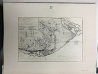
Plan of Quebec at the time of the siege, 1759
Tags
J.B. (Jules Benoît) Livernois (1830-1865)
,
LCC_LAC1
,
Maps
,
Reproductions
,
Thomas Jeffreys (1695?-1771)
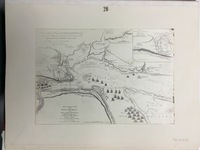
Plan of the St. Lawrence, Quebec and operations of the siege, 1759
Tags
J.B. (Jules Benoît) Livernois (1830-1865)
,
LCC_LAC1
,
Maps
,
Reproductions
,
Thomas Jeffreys (1695?-1771)
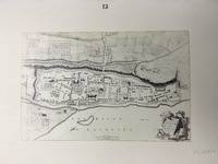
Plan of Montreal or Ville-Marie and fortifications, 1758
Tags
J.B. (Jules Benoît) Livernois (1830-1865)
,
LCC_LAC1
,
Maps
,
Reproductions
,
Thomas Jeffreys (1695?-1771)
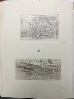
[Battles between the French and English at Quebec]
Titles from the index: "Battle near Lake George" and "Plan of Quebec attacked by the English 1691".
Tags
J.B. (Jules Benoît) Livernois (1830-1865)
,
LCC_LAC1
,
Louis Armand de Lahontan (1666-1716)
,
Maps
,
Reproductions
Output Formats
atom
,
dc-rdf
,
dcmes-xml
,
json
,
omeka-xml
,
rss2